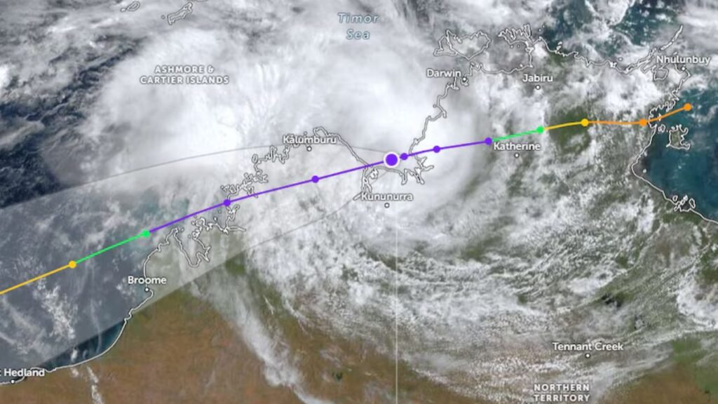
Ex-Tropical Cyclone Narelle is once again drawing attention as it moves west across northern Australia, with forecasts indicating it could redevelop into a tropical cyclone later this week. The system, which weakened into a tropical low after crossing the Northern Territory, is now positioned over the Joseph Bonaparte Gulf near the Western Australia–Northern Territory border.
According to the Bureau of Meteorology (BOM), the weather system is currently travelling west at approximately 16 kilometres per hour and is expected to move into the Indian Ocean, where conditions may allow it to regain strength.
Potential Impact on WA Coastline
Forecasters warn that the Pilbara and Midwest regions of Western Australia could be affected if the system intensifies. There is even a possibility that it could strengthen significantly, potentially reaching category four cyclone status later in the week.
Authorities have already issued alerts:
- Watch Zone: Kimberley region from Beagle Bay to southwest of Mitchell Plateau
- Warning Zone: Between Mitchell Plateau and the WA/NT border
Residents in these areas are being urged to stay informed and prepare for rapidly changing weather conditions.
Heavy Rain and Strong Winds Expected
Even before any potential re-intensification, the system is already bringing hazardous weather conditions. Meteorologists predict:
- Wind gusts up to 100 km/h
- Heavy rainfall reaching up to 200 mm
- Increased risk of flash flooding
Officials have warned residents not to underestimate the dangers of floodwaters. Driving through flooded roads remains one of the most significant risks during such weather events.
Emergency Services on High Alert
The Department of Fire and Emergency Services (DFES) is closely monitoring the situation and coordinating with local communities and tourism operators. Authorities have taken precautionary steps, including:
- Pre-positioning emergency equipment
- Preparing to deploy additional personnel if required
- Maintaining communication with remote communities
These measures aim to ensure a rapid response if conditions worsen.
Remote Communities Preparing for Impact
Communities in northern Western Australia, including Kalumburu—the state’s northernmost settlement—are already in the warning zone and preparing for potential impacts.
Local leaders have stated that residents are experienced in dealing with such weather events and have implemented standard flood preparation measures. While heavy rainfall is expected, the region’s sandy soil allows water to drain relatively quickly, reducing prolonged flooding risks.
There have been minor disruptions, such as delays in food supply deliveries. However, officials have reassured residents that essential supplies remain sufficient, with packaged and canned goods available until fresh produce arrives.
Possibility of Cyclone Redevelopment
The Bureau of Meteorology has indicated a high likelihood that the system will regain cyclone strength by midweek once it moves offshore. However, there is still uncertainty regarding its exact path and intensity.
Forecasters suggest that the system could:
- Continue moving west into open waters
- Curve back toward the WA coastline
- Potentially make landfall later in the week or next weekend
Due to these uncertainties, authorities are urging residents to monitor updates closely.
Uncertainty Remains a Key Concern
Weather systems in this region can be unpredictable, and while forecasts provide guidance, conditions can change quickly. Experts emphasize that even if the system does not reach full cyclone strength, the associated rainfall and winds alone can cause significant disruption.
Preparedness remains the most effective way to minimize risks.
Ex-Tropical Cyclone Narelle is once again posing a potential threat to Western Australia as it moves toward conditions favourable for redevelopment. With strong winds, heavy rainfall, and the possibility of intensification into a powerful cyclone, communities along the WA coast must remain alert and prepared.
While uncertainty surrounds the system’s exact path, early warnings and coordinated emergency responses are helping to reduce risks. Staying informed and taking precautionary measures will be critical in the days ahead.